
toRadians(double angdeg), which will convert the variable
angdeg in degrees into radians. You will need to do this to both of the parameters entered on the command line.
In this lab you will explore three such projections and compare their resulting distance deformations. You must write a Java program that can be executed in the following manner:
java Projection <Latitude> <Longitude>
which takes two floating-point doubles as input from the command line.
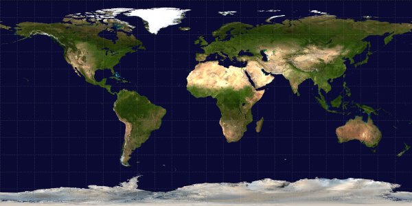 The Equirectangular
projection is a direct translation of latitude and longitude into x, y coordinates. This
is historically the oldest projection, with its biggest strength being that it is very
easy to calculate.
The Equirectangular
projection is a direct translation of latitude and longitude into x, y coordinates. This
is historically the oldest projection, with its biggest strength being that it is very
easy to calculate.
Given a Latitude phi and Longitude lambda and using the Prime Meridian as the center of the map, we can find the x, y ordered pair projection by:
Calculate these x and y coordinates in Java, and display the output to the screen in the following format
EQUI: x = ???, y = ???
where the ??? are replaced by the calculated coordinates.
 The Mercator Projection,
formulated in 1569 by Gerardus Mercator,
is the most commonly used projection and is seen on elementary school walls across America. It has
the property that compass bearings are accurately displayed, and is extremely useful for
nautical purposes.
The Mercator Projection,
formulated in 1569 by Gerardus Mercator,
is the most commonly used projection and is seen on elementary school walls across America. It has
the property that compass bearings are accurately displayed, and is extremely useful for
nautical purposes.
Given a Latitude phi and Longitude lambda and using the Prime Meridian as the center of the map, we can find the x, y ordered pair projection by:

Calculate these x and y coordinates in Java, and display the output to the screen in the following format
MERC: x = ???, y = ???
where the ??? are replaced by the calculated coordinates.
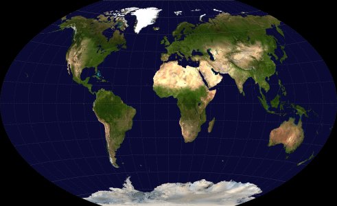 The Winkel Tripel
projection was adopted by the
National Geographic Society in 1998 as their official project. It is an average of
two other projections, and provides a low amount of individual distortion across the whole map.
The Winkel Tripel
projection was adopted by the
National Geographic Society in 1998 as their official project. It is an average of
two other projections, and provides a low amount of individual distortion across the whole map.
Given a Latitude phi and Longitude lambda and using the Prime Meridian as the center of the map, we can find the x, y ordered pair projection by:

Calculate these x and y coordinates in Java, and display the output to the screen in the following format
WT: x = ???, y = ???
where the ??? are replaced by the calculated coordinates.

Calculate the distance between your given latitude and longitude points for each pairing of the three discussed projections. Display this output to the screen in the following format
EQUI vs MERC: ???
EQUI vs WT: ???
MERC vs WT: ???
where the ??? are replaced by the calculated distances.
ssh username@cs.centenary.edu to connect with the cs server.
mkdir csc204/lab1
chmod 700 csc204/lab1
setfacl -m u:mgoadric:rx csc204/lab1
logout
cd csc204
scp Projection.java username@cs.centenary.edu:"csc204/lab1"
scp lab1_evaluation.txt username@cs.centenary.edu:"csc204/lab1"